
Vision2Slope: estimating urban road slopes with street view imagery
Road slope is a critical yet underrepresented variable in urban analysis. This study presents Vision2Slope, a scalable framework that uses panoramic street view imagery and …
Yang CHEN (陈阳) is a PhD candidate at Nanjing Normal University, China, with expertise in GIS, Remote Sensing, and Cartography, as well as an interdisciplinary background in geomorphology and terrain modeling. His research focuses on urban modeling and urban morphology by leveraging multi-source geospatial data, such as street view imagery, digital elevation models, and remote sensing imagery. Recently, Yang’s work has concentrated on estimating building heights at the footprint level using machine learning methods and reconstructing the 3D typology of road networks on a large scale. He is also involved in projects that integrate urban analytics with environmental sustainability. He aims to contribute to sustainable urban development through innovative data-driven solutions.
Visiting Scholar in Urban Analytics Lab
College of Design and Engineering, National University of Singapore
PhD Candidate in Cartography and Geographic Information Systems
School of Geography, Nanjing Normal University, China
BSc Geographic Information Science
Zhejiang Agriculture & Forest University, China
I’m a scholar in the Digital Terrain Analytics team at Nanjing Normal University. And now, I am a visiting scholar at the UAL, National University of Singapore. My research focuses on the intersection of Geography, Computer Science, and Urban Science.
I apply a range of qualitative and quantitative methods to comprehensively investigate the urban issues and artificial landscape.
Please reach out to collaborate 😃
One hour coding a day, keep the bugs away. 🐞
Road slope is a critical yet underrepresented variable in urban analysis. This study presents Vision2Slope, a scalable framework that uses panoramic street view imagery and …

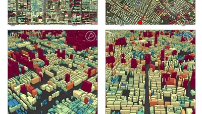
This study introduces a 3D framework for assessing 15-minute accessibility in Nanjing, China. Using natural language processing and rule-based methods, we construct a 3D functional …

Anthropogenic forces have become a significant factor in the development of geomorphology, influencing landform morphology and usage in diverse ways across natural and societal …
This study bridged this gap by using random forest models to integrate the elevation, geometry and shape attributes of individual buildings, further refining those with spatial …