A comprehensive vision-based framework for understanding nation-wide urban socio-demographics

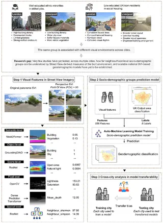 Framework for inferring socio-demographic groups from street view imagery and evaluating cross-city transferability.
Abstract
Understanding geodemographic distribution across neighbourhoods is essential for identifying socio-spatial differentiation in cities. Traditional geodemographic classification studies rely primarily on various census and socioeconomic data, offering limited insight into the street-level environments through which such differences are experienced and reproduced. In particular, the visual and perceptual dimensions of neighbourhoods remain largely absent from existing classification frameworks. This study advances geodemographic classification research by introducing street view imagery (SVI) as a novel source for capturing latent visual features linked to socio-spatial structure. We propose an automated machine learning framework that leverages 556 image-derived variables to predict socio-demographic groups. The framework is applied in ten UK cities, where a national model and local instances are developed to assess the extent to which visual-demographic relationships are place-dependent or generalizable. Results show that SVI has potential for capturing geodemographic patterns and enabling national-scale generalization. The local model achieves an accuracy ranging from 0.49 to 0.70, while the national model brings an accuracy of 0.62. Finally, cross-city transfer analysis reveals both shared and heterogeneous visual–demographic relationships across urban contexts. This study contributes a new street-level observational layer that complements traditional data sources and extends the methodological scope of geodemographics, while informing improvements to public spaces and supports policy objectives aimed at fostering inclusive neighbourhood environments.
Type
Publication
Cities, 179, 107657
