Revealing the co-occurrence patterns of public emotions from social media data
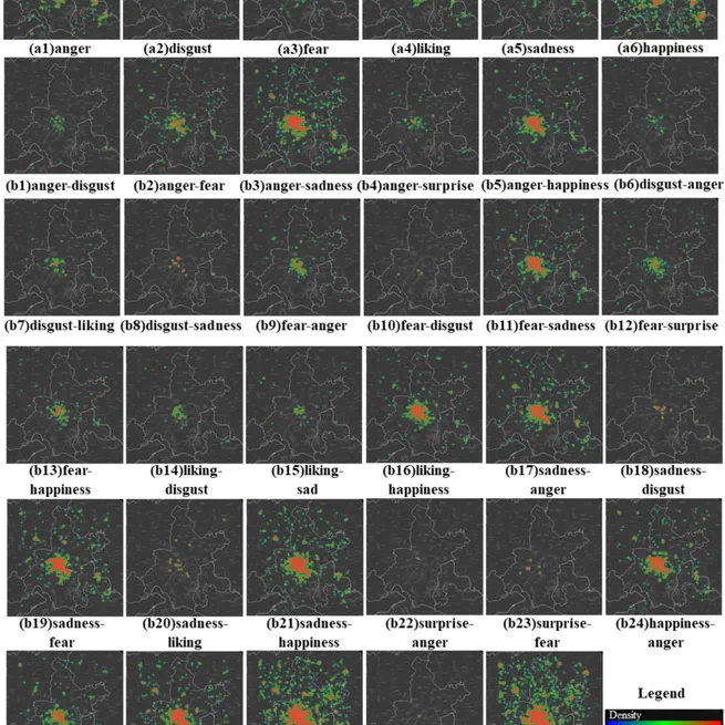
This study proposes a framework that integrates deep learning with co-occurrence theory to classify public emotions from social media data into single, dominant-subordinate, and compound classes. The method identifies 34 types of complex emotions and reveals associations between urban environmental factors and emotional distribution. Compared to valence-based methods, it effectively captures changes in public emotions following a respiratory infectious disease outbreak, demonstrating robust stability across spatial scales.
Mar 11, 2026
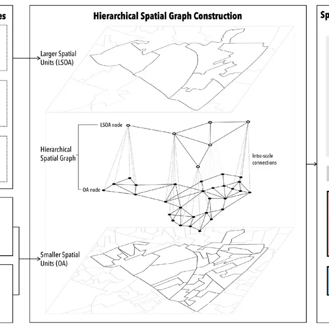
A graph neural network for small-area estimation: integrating spatial regularisation, heterogeneous spatial units, and Bayesian inference
Lunar craters are important geomorphological features, that provide valuable insights into lunar morphology, geology, and impact processes. However, the current understanding of lunar craters of different sizes, especially smaller craters (diameter <5 km), is still incomplete. The lack of understanding of small lunar craters affects our understanding of the lunar surface and its geological history. Therefore, in this study, we propose a deep learning Crater Detection Algorithms (CDA), called Lunar Topographic Knowledge Attention U-Net (LTKAU-Net) that integrates a Digital Elevation Model (DEM) and topographic knowledge.
Dec 29, 2025
Vertical 15-minute city: Modeling urban density and functional mix with multi-source geospatial data
This study introduces a 3D framework for assessing 15-minute accessibility in Nanjing, China. Using natural language processing and rule-based methods, we construct a 3D functional composition dataset from multi-source data. We then develop floor-level proximity indices that account for both horizontal travel time and vertical circulation (e.g., stairs, elevators). Analyzing over 90 million simulated trips, we find that accessibility generally declines with building height, though access to offices and commercial facilities improves at 20th or higher floors. Spatial inequalities emerge not only between central and peripheral zones but also across building levels and regional GDP levels, with a U-shaped disparity tied to distance from downtown. Notably, 11%–17% of trips considered accessible in 2D analyses exceed the 15-minute threshold when vertical travel is included. Our findings highlight the need to incorporate vertical space in 15-minute city evaluations and offer a scalable method to support inclusive, fair, and livable 3D urban planning with the background of 15-minute city.
Oct 6, 2025
A typology of global relief classes derived from digital elevation models at 1 arcsec resolution
Surveys of global relief classes are important for understanding the morphology and land processes of Earth's surface. This study proposes a novel framework integrating the accumulated slope and a new surface relief index for global relief classification (GRC) with 1 arcsec resolution. This dataset can provide abundant and detailed land surface information for the field of Earth sciences.
Sep 5, 2025
Understanding the hydrological valley landscape: A multi-scenario adaptive framework for delineating valley floors
May 7, 2025
Characterizing spatial patterns and regionalization of anthropogenic landforms using multi-source geospatial data: Insights from Loess Plateau of China
Anthropogenic forces have become a significant factor in the development of geomorphology, influencing landform morphology and usage in diverse ways across natural and societal environments. Despite their growing impact, few studies have quantified the morphology and distribution of anthropogenic landforms at large scales to reveal the spatial patterns of human modification on the surface. To address them, we propose a framework that includes three classical anthropogenic landforms, i.e., terraces, check dams, and impervious surfaces, on the Chinese Loess Plateau (CLP) to measure the morphology differences at the basin level. This research provides a new perspective and robust methodological framework for analyzing the morphology pattern of anthropogenic landforms. It could be a data foundation for future studies exploring the interactions between human activities and geomorphological processes.
Mar 7, 2025
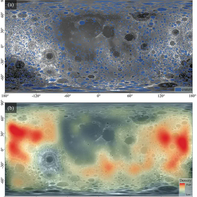
Deep learning detects entire multiple-size lunar craters driven by elevation data and topographic knowledge
Lunar craters are important geomorphological features, that provide valuable insights into lunar morphology, geology, and impact processes. However, the current understanding of lunar craters of different sizes, especially smaller craters (diameter <5 km), is still incomplete. The lack of understanding of small lunar craters affects our understanding of the lunar surface and its geological history. Therefore, in this study, we propose a deep learning Crater Detection Algorithms (CDA), called Lunar Topographic Knowledge Attention U-Net (LTKAU-Net) that integrates a Digital Elevation Model (DEM) and topographic knowledge.
Feb 7, 2025
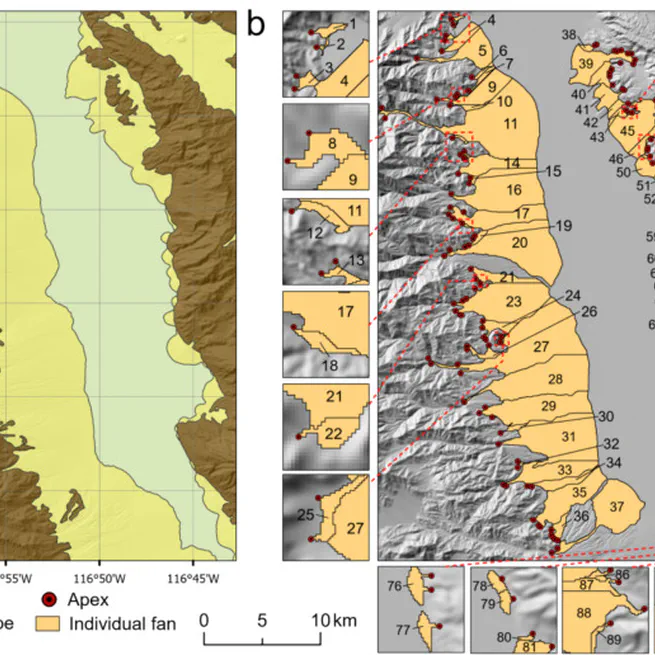
Delineating individual alluvial fans and morphological analysis based on digital elevation models
We proposed a novel method for delineating individual alluvial fans based on free digital elevation models. This method incorporated multi-directional hillshades to accurately extract alluvial slopes, and two flow direction algorithms to support the delineation of individual fans. The method was tested in Death Valley, where a total of 89 individual fans were delineated for morphological analysis.
Jan 27, 2025
Assessing the influence of geo-environmental factors on discontinuous gully erosion at regional scales: A case study of spoon gullies on the loess plateau of China
Spoon gullies, characterized by fat heads and thin tails, are a typical type of discontinuous hillslope gully found extensively on the Loess Plateau of China. This study explores the variations in factor dominance influencing the gully erosion within a global-local framework, using Geodetector, geographically weighted regression, and spatially constrained multivariate clustering. The study provides new insights into the spatial heterogeneity of discontinuous gullies at a regional scale and offers implications for developing targeted strategies against gully erosion.
Dec 31, 2024
Is 3D building morphology really related to land surface temperature? Insights from a new homogeneous unit
This study places special emphasis on proposing a new spatial unit, the Homogenous Unit of Building Morphology (HUBM), to re-describe building morphology and re-analyze its effect on LST with less uncertainty.
Dec 1, 2024